 Here are the details of maps for Aberystwyth:

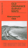
This detailed map was our first title in Wales. It covers most of this university town, and features include the Cambrian station, engine sheds, Vale of Rheidol station, Pont Aberystwyth, University College (in town, not today's buildings), St Michael's church, Royal Pier Pavilion, castle ruins, Marine Terrace, Workhouse, Queen's Hotel, old quarries, Cliff Railway. Constitution Hill is at the top of the map. Extracts from a directory are included, and the notes are bilingual. There is also a short intro to the carto-bibliography by Richard Oliver, trans. Nansi Thirsk.