
Old Ordnance Survey Maps of Doncaster MBC
This is our coverage of Doncaster, historically part of the West Riding of Yorkshire. Today's Metropolitan Borough of Doncaster dates from 1974 and the amalgamation of the
County Borough of Doncaster with Adwick le Street Urban District, Bentley with Arksey Urban District, Conisbrough Urban District, Mexborough Urban District,
Tickhill Urban District, Doncaster Rural District and Thorne Rural District. At the same time it became part of the new South Yorkshire Metropolitan County. Since 1986 it has been a unitary authority.
All maps are available from our On-line Mapshop.
The following titles are taken from the OS 25" maps and reduced to a scale of approximately 14 inches to the mile.
They are extremely detailed, showing individual houses, details such as railway tracks, pathways,
pubs, factories and even minutiae such as fountains and signal posts. Each covers an area of a mile and a half by one mile, and includes an introduction.
These are the maps for Doncaster in our Yorkshire series:
277.13 a Doncaster (North) 1906 - published 1984; intro by Clive Howarth
277.13 b Doncaster (North) 1929 - published 2006; intro by John Gough
285.01 a Doncaster (South) 1901 - published 1984; intro by Clive Howarth
285.01 b Doncaster (South) 1928 - published 2006; intro by John Gough
284.09 Mexborough 1901 - published 1986; intro by Norman Watson
284.10 Conisbrough 1901 - published 1985, 2nd Ed 2001; intro by Alan Godfrey
291.10 Tickhill 1901 - published 2004; intro by Melvyn Jones
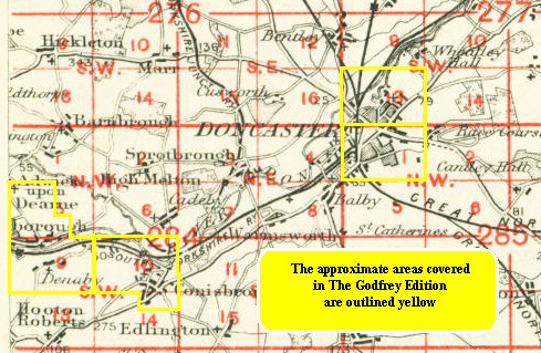
The following index map might also be useful: Doncaster index map
We also publish a series of small scale Inch to the Mile maps covering most of the country. The following is the principal sheet for the Doncaster area:
88 Doncaster & Isle of Axholme 1894- published 2001; in tro by Melvyn Jones. Includes a map of Finningley.
For further details of our One Inch Maps, visit the One Inch page.
 Most maps in the Godfrey Edition are taken from the 25 inch to the mile map and reduced to about 15 inches to the mile.
For a full list of English maps, return to the England page
You can order maps direct from our On-line Mapshop.
Most maps in the Godfrey Edition are taken from the 25 inch to the mile map and reduced to about 15 inches to the mile.
For a full list of English maps, return to the England page
You can order maps direct from our On-line Mapshop.
Alan Godfrey Maps, Prospect Business Park, Leadgate, Consett, DH8 7PW. Tel 01207 583388
The Godfrey Edition / sales@alangodfreymaps.co.uk / 24 January 2018