Old Ordnance Survey Maps of Dunbartonshire

  • These detailed maps normally cover an area of about one and a half miles by one mile. Each map includes an introduction.
  • They are available through our On-line Mapshop

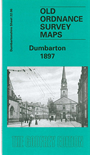
  • Here are the details of maps for Dumbarton:

  • Dumbartonshire Sheet 22.06 Dumbarton 1897 - published 2002; intro by Gilbert Bell. ISBN.978-1-84151-461-1

    This detailed map covers much of the town of Dumbarton, with coverage from High Street eastward to Crosslet.

    Features include most of town centre with buildings neatly delineated, Dock Yard, NBR railway with station, stretch of Lanarkshire & Dumbartonshire Railway, Dumbarton East station, Knoxland area, mineral railways, Leven Shipbuilding Yard, Tidal Basin, Meadow Park, Dumbarton Rope Works, Lennox Rope Works, Dumbuck House (in SE corner of map), Crosslet, Gruggies Bridge etc. We include some extracts from a contemporary trade directory on the reverse.


  • Follow this link for a complete list of our Dunbartonshire maps.
  • You can order maps direct from our On-line Mapshop. For other information and prices, and other areas, go to The Index Page.
  • Maps in the Godfrey Edition are taken from the 25 inch to the mile map and reduced to about 15 inches to the mile. For a full list of maps for Scotland, return to the Scotland page.
    The Godfrey Edition / sales@alangodfreymaps.co.uk / 11 November 2016