We have published more than 2,400 maps in our series of Old Ordnance Survey Map reprints; this includes more than 150 in Scotland, with a growing range of maps around Glasgow. The maps are highly detailed. They are taken from the OS 1:2,500 (or 25 inch) maps and reduced to about 15 inches to the mile. Each covers an area of a mile and a half by a mile. They show streets with individual houses, tram tracks, railway tracks and even signals, factories, wharves and such details as fountains and water troughs. They will provide hours of fascination for historians and genealogists. The maps are neatly folded and each includes a specially written introduction to the area. Maps can be purchased on our On-line Mapshop where further information about titles is given. Or visit The Index Page for a full list to the series and details of Prices.
Here are the details of maps for Clydebank:
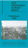
This detailed map covers the important industrial village of Clydebank, with coverage stretching from the Kilbowie Factory southward to the Old Canal and Hamilton Free Church.
Features include Kilbowie Sewing Machine Factory, Clydebank Engineering & Shipbuilding Works, dock, Kilbowie Iron Works, Forth & Clyde Canal, NBR railway with Kilbowie station, Lanarkshire & Dumbartonshire Railway with station, Glasgow Yoker & Clydebank Railway with terminus, railways into dock, chemical works, etc. On the reverse we include extracts from a trade directory.
Follow this link for a complete list of our Dumbartonshire maps.
You can order maps direct from our On-line Mapshop. For other information and prices, and other areas, go to The Index Page.
Maps in the Godfrey Edition are taken from the 25 inch to the mile map and reduced to about 15 inches to the mile. For a full list of maps for Scotland, return to the Scotland page.
The Godfrey Edition / godfreyedition@btinternet.com / 9 Dec 2010