Old Ordnance Survey Maps of Sunderland

  • These detailed maps normally cover an area of about one and a half miles by one mile. Each map includes an introduction.
  • They are available through our On-line Mapshop

  • Here are the details of maps for South Hylton:

  • Co Durham Sheet 7.16 South Hylton 1895 - published 2014; intro by Alan Godfrey. ISBN.978-1-84784-761-4

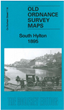
    This very detailed map covers South Hylton and much of North Hylton.

    Features include South Hylton village with individual buildings neatly shown, NER railway with Hylton station, South Hylton Iron Works, Low Ford Dock, Leopard pub, Rentforth Hotel, several other pubs, North Hylton, Naptha Manufactory, shipbuilding yard, Wood House, cement works, Hylton Grange, Low Barmston etc. 1894 and 1906 directories of South Hylton are included on the reverse.

    This map links up with Sheet 8.13 Pallion to the east.


  • Follow this link for a complete list of our Sunderland maps.
  • You can order maps direct from our On-line Mapshop. For other information and prices, and other areas, go to The Index Page.
  • Maps in the Godfrey Edition are taken from the 25 inch to the mile map and reduced to about 15 inches to the mile. For a full list of maps for the North East, return to the North East page.
    The Godfrey Edition / sales@alangodfreymaps.co.uk / 25 October 2017