 Easingwold is typically described as an "unspoilt Georgian North Yorkshire market town nestling in the shade of the rolling Hambleton hills", "on the western side of the Howardian hills", or as "a fantastic touring centre" and "gateway to the North York Moors". Much of the town is now a conservation area, and - as with a few other North Yorkshire towns - there is sometimes a sense of life having come to a standstill until the next film crew arrives.
Easingwold's history deserves rather more than that. It was recorded in the Domesday survey as Eisecewalt, with a church, a priest and around ten families. The origins of the village go back further, with its name having Anglo Saxon origins, later spellings including Eisinceuuald (11th century), Hesingwald (12th) and Esyngwold (16th century). It was granted a market charter in 1221, though this does not appear to have brought great prosperity, and may not have been held regularly. The manor stood within the royal Forest of Galtres, and was assigned over the years to various members of the Royal Family, including Countess Eleanor of Leicester - wife of Simon de Montfort - in 1259; Earl Henry of Lancaster in 1327; Joan de Ferrers, daughter of John of Gaunt, in 1397; before reverting back to the king, Henry VI, in 1440. More significant change came in 1616 with James I granting the manor to his son Charles, Prince of Wales, and when the latter ascended to the throne he became so eager to raise funds that he attempted to sell the manor to a consortium of City of London trustees. This led to protests and confusion, with claims that the Forest of Galtres had already been sold, but after some local negotiations the manor was granted in the early 1630s to Thomas Belasyse, 1st Viscount Fauconberg (1577-1653), a Royalist supporter who was forced to flee into exile following the battle of Marston Moor in 1644. He later returned, was buried at Coxswold, and was succeeded by his son, Thomas Belasyse, the 2nd Viscount and 1st Earl Fauconberg (c.1627-1700), who would later marry Mary, second daughter of Oliver Cromwell. The manor remained with the family until it passed to Sir George Wombwell, Bt (1769-1846) on his marriage to Lady Anne Belasyse. Sir George pops briefly into the cricketing history footnotes, playing one First Class match for the MCC in 1792, when he scored 19. He was succeeded by his son, also Sir George Wombwell, 3rd Baronet, and then Sir George Orby Wombwell, 4th Baronet (1832-1913), a survivor of the Charge of the Light Brigade and sometime High Sheriff of Yorkshire, who is also buried at Coxswold. His sons died on active service and he was succeeded by his younger brother, Henry Herbert Wombwell.
The lord of the manor - of Easingwold & Huby - was clearly an absentee, but the town also had an ecclesiastical manor, which had been granted to the archdeacons of Richmond by 1269. This manor comprised around 32 acres in Easingwold, and 16 more at Raskelf, providing income for the clergy, and it passed to the bishops of Chester following the founding of that diocese in 1541, and to the archbishop of York in 1974. A manor house was noted at the foot of Church Hill, but had probably fallen into disrepair by 1317. A subsequent hall was built, sometimes known as the parsonage house and often leased out; in 1534 a Richard Collynson was forcibly ejected by a force of 19 armed men, apparently as the culmination of a lease dispute. In the 17th century the archdeaconry manor was leased to the Driffield family, wealthy, litigious and with a sense of their importance, and in 1625 the manor house was described as "An antient manse or rectory house with two Barnes a dovecote and an oxhouse with a yeard and backside" .Despite some rebuilding it retained medieval features and became known as the Old Hall. Tenants included Thomas Raines (or Rayns), sometime Lord Mayor of York, who took a lease of the archdeaconry manor from Towers Driffield in the 1680s. There is a memorial to Raines, who was afflicted with paralysis in his later years, in the parish church. The hall was later occupied by several generations of the Salvin family, including Thomas Salvin, who succeeded to the estate in 1765 and was described as an officer in the Imperial or Austrian army, a traditional army career for a Catholic. It was sublet to Sir William Vavasour in the early 19th century but was demolished c.1835 to be replaced by a "very unadorned farm-house". In 1852 Thomas Gill recorded that "nothing now indicates its ancient dignity but the garden walls, the fish pond, and a few very old Weymouth pines".
Nothing now survives of the Anglo Saxon church mentioned in Domesday Book, but a stone-built church existed by c.1150 and fragments of this have been found during building work. Today's church was entirely rebuilt between 1388 and 1418 while Thomas Dalby and Stephen le Scrope were archdeacons of Richmond; their arms can be found in the stonework beneath the north aisle windows. A tower was added in the late 15th or early 16th century. The church was restored in 1858, when the chancel roof was heightened, and the west gallery dates from this time. Further restoration took place in the late 20th century. The church is notable for several good monuments, while outside the chancel door is the tombstone to a former Blue Bell Inn landlady, Ann Harrison, locally known as Nanna Rann Dann, with its enigmatic inscription: "She was chaste but no bride"; schoolboy legend says that she will emerge if you run three times round the grave and then spit. A curiosity inside is the parish coffin, one of very few survivors; the bodies of the poor would be carried to their grave in this, the body then being lowered into the grave. The church has been variously dedicated to St John the Baptist and All Saints across the years - the map gives it as the former - but to end the confusion it was formally dedicated to St John the Baptist & All Saints in 1988.
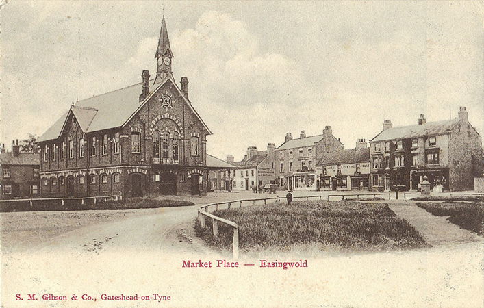
The church is a surprising distance from the town, which developed in the early 17th century following the revival of the market. Easingwold as shown here is an amalgam of three areas: Uppleby, an upper town settled in the 10th century by a Danish farmer known as Upple, and today a wide, tree lined street with brick cottages behind a grassy verge; a "lower town" along Long Street, which became Easingwold's main thoroughfare; and a spacious Market Square at the centre, partly cobbled and surrounded by late Georgian buildings. The town has no great buildings - the church has the only Grade II* listing - but it has a great many good ones, and the centre is popular with its cafes and shops, even though the latter are concerned increasingly with tourism.
A few buildings around the Market Place deserve mention here. Moving clockwise we note the Old Vicarage, built 1771 to replace a building destroyed by fire, extended and later itself replaced by the Victorian vicarage on Church Hill; the National School, built 1862 and with the warning "Learn or Leave" above the door, but now Easingwold's library; the Commercial Inn, late 18th or early 19th century and one of the town's many Grade II listed buildings; the White House, perhaps Easingwold's finest Georgian house, probably dating from the mid-18th century, with "bold overhanging eaves and a well-proportioned facade" according to Mark Reid, and sometime home to the Whytehead family; the single-storey Victoria Institute, built 1897 as a community centre; the George Hotel, with its own claims to being a coaching inn; Galtres, built by Demaine & Brierley of York for the Robinson family in 1897 but now a community centre; and Rocliffe House, on the west of the square, mid- to late-18th century, once home to Dr William Rocliffe (d.1839), a surgeon and physician, notable for wearing a powdered wig and knee breeches long after they had gone out of fashion, and the subject of many stories, mostly of the "hunting, shooting and fishing" variety, and with a special interest in cock-fighting.
Much of the land within the Forest of Galtres was enclosed in the 1640s, many trees were felled, and the town became a centre for dairy farming and pig rearing. This led to a revival of the market and development of the Market Place. In 1639 George Hall obtained the rights - "Letters Patent under the Privy Seal" - to hold a free market every Friday, together with two wakes or fairs. In 1646 part of the Market Place was conveyed to Hall for a market, while he agreed to provide a tollbooth and maintain the pavement. The site until then was probably little more than an open space, with a bull ring for the baiting of bulls, a ducking stool and other minor pleasantries. The inhabitants of the manor were to be free of all market tolls, a privilege that would lead to a long-lasting dispute in the 19th century, Gill noting that it had "been argued four times at York, and six times at Westminster, on points which the courts, after all, had left open to further argumentation". In 1922 the local branch of the British Legion acquired the market rights and conveyed them to the parish council. The Friday market continues today and is one of the most popular in the region. In the centre of the square are the Victorian Town Hall, built 1864 in red and yellow brick and such a contrast to the Georgian houses around that a horrified Pevsner described it as "a brute"; the clock tower was added later. The building was used for petty sessions, for an annual court leet, and for various meetings and assemblies. A Market Cross stands beneath a shelter, and little tea rooms add to the ensemble, though today we might regret that so much of the square is taken up with parking.
Some modest suburbia immediately east of this map included the Workhouse, for Easingwold had become the centre of a Poor Law Union in 1837. There had been a parish workhouse in Uppleby since at least the 1750s and this is recorded as having been quite strict in the 1820s, with men, women and children segregated, heating provided only by permission of the Vestry, and lighting (ie candles) provided only for the sick. The new Easingwold Union covered 35 parishes and townships. The workhouse itself, on Oulston Road east of the map, was opened in October 1838; it had room for 130 inmates. An infirmary was added in the 1860s. The rural district met there on alternate Fridays, as well they might, for its chairman, clerk and treasurer served the same roles on the Union Board of Guardians. The workhouse became Claypenny "Colony" in 1934, providing facilities for people with learning difficulties, and has since been converted into apartments.
Easingwold's industry was largely confined to a tannery and handful of shoemakers, but in the late 18th century it grew prosperous on the back of the coaching trade, the population rising to 1,467 in 1801 and 1,912 by 1821. The town stood on the main road from York to Newcastle and was a natural first stop for stagecoaches travelling north. The York to Northallerton road was turnpiked in 1753, with several official improvements and renewals over the years until the turnpike trust was wound up in 1875. At its peak there are said to have been 26 inns to serve travellers, either around the Market Place or along Long Street, which formed part of the A19 until a by-pass was built in 1994. The coaching trade developed in the 1780s, when the principal coaching inns for through traffic were the New Inn, which served as the excise office, and the original Rose & Crown. Major coaches noted by Cowling included the Edinburgh Mail Coach - the Mail, with its liveries and emblems of office - which ran from 1786, passing through Easingwold northbound at about 2 am and southbound around 7.30 pm. From 1788 there was a rival but independent coach, the Highflyer, also travelling to Edinburgh, which appears to have stopped alternately at the New Inn and the Rose & Crown. By the 1830s there were several other coaches, the principal ones being the Wellington and the Express, both travelling from York to Newcastle and with stabling at or across from the New Rose & Crown, at the corner with Little Lane, a building which became a convent in 1905 and has since been converted into apartments. Coaches to Teesside and Wearside included the Royal Times to Redcar and Sunderland, and a Sunderland Mail. Along with these would have been local carriers and carters, providing the connections to and from the villages, and goods carriers such as Richard Pickersgill of Leeming Lane, who ran services across much of the north.
These were heady days but much of the trade would be killed off in a matter of months by the railways. Acts for the Great North of England Railway, for a line from York to Darlington - today part of the East Coast Main Line - were passed in 1836-37, though an Easingwold attorney attempted to have the route changed so that it would pass through or near to his town. He failed in this, and the railway duly opened for mineral traffic on 4th January 1841 and for passengers on 30th March. By the end of 1842 only the Wellington of the major coaches survived, and that faced an uncertain future. The nearest station for Easingwold was Alne, and a guide book in 1843 noted hopefully that "the Alne station of the G.N.of E.Rly. is distant from Easingwold about 3 miles, and it is in contemplation to form a line from that station to the town, which no doubt will add much to the improvement of the place". One of the pubs in the Market Place even renamed itself the Railway Tavern in 1843. As late as 1851 a Bradshaw'smap was indicating a branch railway to Easingwold, and in the 1860s the mighty London & North Western Railway, with its eyes on the NER's territory, envisaged a line from the West Riding to the Tees via Easingwold.
Nothing came of these projects and Easingwold stagnated, so that in 1901 its population was just 1,945, having fallen from the dizzy heights of 2,240 in 1851. There were half-hearted attempts in the 1850s to make use of the town's chalybeate springs, and develop the town as a spa; the water, we are told, "most resembles the Cheltenham Waters and has a ferruginous taste, exciting the appetite, and is recommended for the removal of gout and rheumatism". A Spa Well is noted here about a mile west of the town (plot 551), on the land of William Whytehead, whose family had once owned the market rights, and Gill notes this as smelling of sulphur and "peculiarly suited to the relief of chronic and cutaneous diseases, But Easingwold has not hitherto shown any signs of very formidable rivalship to such neighbours as Harrogate and Hovingham". Race meetings were held in the 1850s, including a meeting known as the "Balaclava Races" in honour of the heroic Sir George Wombwell, but these never began to compete with those at Thirsk or York. Easingwold was in danger of drifting into oblivion.
At last, realising that none of the larger railway companies were interested in serving it, a group of local landowners and tradesmen got together, obtained an Act for a branch from Alne to Easingwold, and arranged a public meeting at the Town Hall, chaired by Sir George O Wombwell, on 8th October 1887. A Mr Copperthwaite Jnr had surveyed the line, which would cost £8,783, to include "a light tank engine [and] two second-hand carriages". It was originally intended to terminate the branch behind Long Street but to save costs a site was chosen further out on the " Vicarage Field".
Construction was simple, but the first contractor, Death & Co, still contrived to go bankrupt before the work was finished. The branch finally opened on 25th July 1891, with around 400 local schoolchildren and teachers being given free rides, followed by tea at the Town Hall and a gathering in the "beautiful grounds"of the Vicarage. A surprisingly large Station Hotel was opened the following year, reflecting the general optimism, and there was also an auction mart, owned by the railway, where cattle sales were held on alternate Mondays. There was a small engine shed at the south end of the complex for the locomotive - a Hudswell Clarke 0-6-0 saddle tank for most of the railway's existence - but in its final years engines were hired in from LNER or BR, and these were too large to go into the shed. At the time of our map passenger rolling stock comprised three former North London Railway 4-wheelers, with 1st and 2nd class compartments; 3rd class fares were available for some trains, with these passengers travelling in 2nd class compartments. There were normally around 8 or 9 trains daily in each direction, but no Sunday service. A shed near the Railway Cottages was used for a North Eastern Railway steam wagon, which ran an Easingwold-Brandsby goods service from 1906 until 1915.
The Easingwold Railway was unusual in remaining independent throughout its life, being ignored both at grouping and nationalisation. It was formally made a Light Railway in 1928, but this probably did little except confirm the way it had always been run (without signalling, for instance). For much of its existence the line was profitable, with regular dividends - 4% in 1910 - but these dried up in the 1930s as road competition began to eat away at passenger receipts. Freight traffic in the wars brought renewed prosperity, and a dividend was paid again in 1943, but passenger traffic then all but dried up. At its peak there had been a staff of 12 - two drivers, one fireman, one station master, two clerks, four porters and two platelayers - but by 1948 this had been reduced to four, with others hired in per diem from British Railways. The passenger service was gradually reduced, with just two trains a day by October 1946, and in 1947 only 636 fare-paying passengers (just one of them travelling 1st class) were carried in the whole year. The service ended on 29th November 1948 but goods traffic (and the occasional excursion) continued until 1957. The Easingwold Railway then went into voluntary liquidation, with the last train, conveying the directors, a handful of passengers, and some wagons of sugar beet, travelling to Alne on 27th December that year. The station building was burnt down a few years later and few signs of the railway survive except the Station Hotel, though that is no longer open for business.
The railway came too late to bring a revival of prosperity for Easingwold. Even the grammar school, founded back in the late 18th century, was struggling. It had moved into Longley House - formerly the New Rose & Crown - in the 1890s, but in 1905, with just 30 or so pupils, decamped to an iron building on the Thirsk Road. Longley House was sold to the Sisters of Mercy, and in 1911 the grammar school had to be rescued by the County Education Committee, who agreed to fund the building of new schoolrooms on the understanding that the original endowment be transferred to the County Council. The population of the town did not begin to rise again until the late 20th century, standing at just over 4,000 in the 2001 census. This stagnation, of course, meant that the town stayed much as it had been during its all too brief days of glory, and today it lives up to its billing as a pleasant, unspoilt, Georgian market town.
© Alan Godfrey, March 2014
Principal sources: Geoffrey C.Cowling, The History of Easingwold (reprinted Easingwold, 2001); Thomas Gill, Vallis Eboracensis (1852, reprinted Easingwold, 1974); K.E.Hartley, The Easingwold Railway (Oakwood Press, 1970); Mark Reid, Town Trails: North Yorkshire (InnWay Publications, 2001); Conservation Report (www.hambledon.gov.uk).
Maps in the Godfrey Edition are taken from the 25 inch to the mile map and reduced to about 15 inches to the mile. For a full list of maps for England, return to the England page.
Alan Godfrey Maps, Prospect Business Park, Leadgate, Consett, Co Durham, DH8 7PW / godfreyedition@btinternet.com / 4 Feb 2015