
Old Ordnance Survey Maps of Fermanagh
This is our range of titles in Fermanagh.
All maps are available through our On-line Mapshop.
These are the detailed maps currently available in our County Fermanagh series:
Sheet 22.09 Enniskillen (West) 1936
Sheet 22.10 Enniskillen (East) 1936
 Fermanagh is well covered in our Inch to the Mile series, and these include detailed maps of several smaller towns and villages. These are the maps for the county:
Sheet 32 Belleek, Pettigo & NW Fermanagh 1900
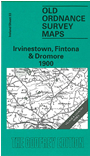
Sheet 33 Irvinestown, Fintona & Dromore 1900
Sheet 44 Derrygonnelly & District 1899
Sheet 45 Tempo & Maguiresbridge 1900
Sheet 46 Augher, Clogher, Aughnacloy 1902
Sheet 56 Swanlinbar 1899
Sheet 57 Lisnaskea & Newtownbutler 1900
 Most maps in the Godfrey Edition are taken from the 25 inch to the mile map and reduced to about 15 inches to the mile.
For a full list of Irish maps, return to the Ireland page
You can order maps direct from our On-line Mapshop.
Most maps in the Godfrey Edition are taken from the 25 inch to the mile map and reduced to about 15 inches to the mile.
For a full list of Irish maps, return to the Ireland page
You can order maps direct from our On-line Mapshop.
Alan Godfrey Maps, Prospect Business Park, Leadgate, Consett, DH8 7PW. Tel 01207 583388
The Godfrey Edition / sales@alangodfreymaps.co.uk / 15 July 2021