Old Ordnance Survey Maps of Kincardineshire
These detailed maps normally cover an area of about one and a half miles by one mile. Each map includes an introduction.
They are available through our On-line Mapshop
 Here are the details of maps for Stonehaven:
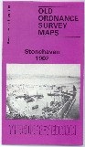
Kincardineshire Sheet 15.16 Stonehaven 1902 - published 1993; intro by David M Bertie. ISBN.978-0-85054-628-8 
This detailed map gives good coverage of Stonehaven, the main town in Kincardineshire. The map is double-sided for maximum coverage.
The main map covers the centre of the town, with coverage stretching from the shoreline westward to part of Fetteresso. Features include Carron Water, ruined church in Fetteresso, Camp Hill, Dunnottar,
Dunnottar House, Woods of Dunnottar, County Temperance Hotel, Poorhouse, town centre with individual buildings neatly shown, railway with station, St Bridget's church, County Buildings, Carron Lodge,
St James church, Market Square Town Hall etc.
On the reverse we include adjacent sheet 16.13 which covers the Harbour, Tollbooth, Bellman's Head, Downie Point.
For other maps in Aberdeenshire visit our Aberdeenshire page.
For information on the local government changes to Aberdeenshire, Banffshire and Kincardineshire visit This Page.
Most maps in the Godfrey Edition are taken from the 25 inch to the mile map and reduced to about 15 inches to the mile.For a full list of Scottish maps, return to the Scotland page.
You can order maps direct from
our On-line Mapshop.
Alan Godfrey Maps, Prospect Business Park, Leadgate, Consett, DH8 7PW. Tel 01207 583388
The Godfrey Edition / sales@alangodfreymaps.co.uk / 7 November 2016