Old OS Town Plans of Liverpool


  • For a few areas of Liverpool and Manchester we have also reprinted some of the very early Five-foot plans. Originally published at a scale of 1:1056 or 5 feet to the mile, we have reduced them in scale to 1:1760 or a Yard to the Mile. The maps, though covering quite a small area, are quite wonderfully detailed, showing such features as capstans and mooring posts, lamp-posts, the layouts of back yards, and even the interior of certain buildings such as churches. For the urban historian they are perhaps the most fascinating maps ever published by the Ordnance Survey.
  • Maps can be purchased on our On-line Mapshop.

  • Here are the details of maps for Liverpool Stanley Dock area:

  • Liverpool Sheet 14 Liverpool (Stanley & Clarence Docks) 1848-64 - published 2009; intro by Kay Parrott. ISBN.978-1-84784-286-2

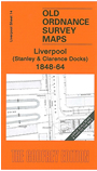
    This wonderfully detailed map covers the area of Liverpool's dockland around Great Howard Street that includes Stanley Dock, Collingwood Dock, Salisbury Dock, Clarence Dock and Basin, the southern part of Nelson Dock, Regent Road, Docks Railway, Dock Police Station, Clarence Warehouses, other stores and warehouses, part of North Dock goods station, New Dockyard Iron Works, Clarence Graving Docks etc. Directories of Dublin Street, Regent Road and Regent Street are included on the revesre.

    The map links up with Liverpool Sheets 18 Liverpool Gt Howard St to the south.


  • Follow this link for a complete list of our Liverpool maps.
  • You can order maps direct from our On-line Mapshop. For other information and prices, and other areas, go to The Index Page.
  • This map is taken from the five foot map and reduced to a scale of a yard to the mile. For a full list of maps for the North West, return to the North West page.
    The Godfrey Edition / sales@alangodfreymaps.co.uk / 18 January 2018