Old OS Town Plans of Liverpool


  • For a few areas of Liverpool and Manchester we have also reprinted some of the very early Five-foot plans. Originally published at a scale of 1:1056 or 5 feet to the mile, we have reduced them in scale to 1:1760 or a Yard to the Mile. The maps, though covering quite a small area, are quite wonderfully detailed, showing such features as capstans and mooring posts, lamp-posts, the layouts of back yards, and even the interior of certain buildings such as churches. For the urban historian they are perhaps the most fascinating maps ever published by the Ordnance Survey.
  • Maps can be purchased on our On-line Mapshop.

  • Here are the details of maps for Liverpool Crown Street:

  • Liverpool Sheet 31 Liverpool Crown Street 1848-64 - published 2023; intro by Alan Godfrey. ISBN.978-1-78721-668-6

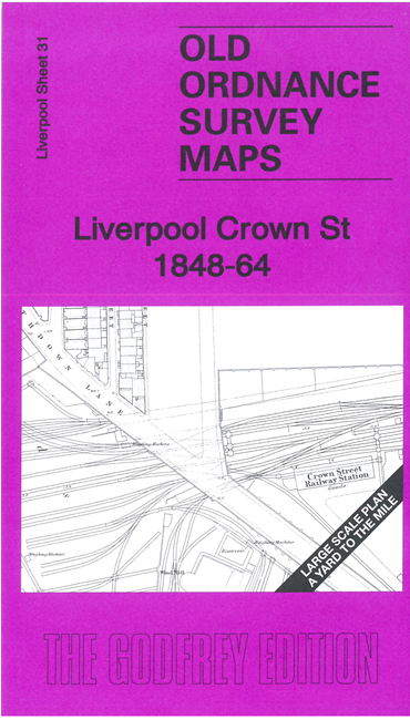
    This wonderfully detailed map covers the area of Liverpool around and to the north of Crown Street station. The map was surveyed in 1848 but railway information was updated to 1864.

    Features include the railway goods yard, entrance to Wapping Tunnel, St Ann's RC Chapel, St Catherine's Church, Female Orphan Asylum, part of Abercrombie Square. On the reverse we include 1:500 plan 15.12 covering the Wapping Cutting area in detail in 1890.

    The map links up with Liverpool Sheets 30 Liverpool Mount Pleasant to the west, 32 Edge Hill Station to the east.


  • Follow this link for a complete list of our Liverpool maps.
  • You can order maps direct from our On-line Mapshop. For other information and prices, and other areas, go to The Index Page.
  • This map is taken from the five foot map and reduced to a scale of a yard to the mile. For a full list of maps for the North West, return to the North West page.
    The Godfrey Edition / sales@alangodfreymaps.co.uk / 25 July 2023