
Old Ordnance Survey Maps of London
These detailed maps maps normally cover an area of about one and a half miles by one mile. Each map includes an introduction. The London maps link up with those for Middlesex to form a major series for the Greater London area. They
are available through our On-line Mapshop
 Here are the details of maps for Southfields:
London Sheet 123.2 Southfields & Wimbledon Park 1867 - published 2000; intro by Pamela Taylor. ISBN.978-1-84151-205-1  London Sheet 123.3 Southfields 1913 - published 1993; intro by Anthony Shaw. ISBN.978-0-85054-596-8
We have published two versions of this map, showing how the area developed across the years. The maps each cover the same
area, from Putney Heath eastward to Merton Road, and from Wincanton Road and Brathway Road southward to Ryfold Road and St Luke's church.
Development of the 'Wimbledon Park' Estate followed the sale of the land by the 4th Earl Spencer to John Augustus Beaumont in 1846. The two maps are quite different so here are brief notes on each:
By the 1860s an estate of 'stately villas' had been built. These are shown on the 1867 map, in their leafy grounds, while further east 'South Field' is largely rural, and aspects of
Capability Brown's park can be seen. This is a most attractive map, with a few large houses shown at the top on Putney Heath: Fireproof House, Highlands, Bristol House.
At the foot is an area called Parkside. Fine villas line the east side of the Heath - Belmont, Albermarle Lodge, etc - and also on Inner Park Road and Victoria Road.
Further east 'South Field' is almost entirely rural, while to the south are remnants of Capability Brown's landscaping, with The Lake. The short directory Wimbledon Park lists the gentry who lived here.
The Wimbledon & Fulham railway arrived in 1889 and a much more routine suburb developed around
Southfields station. By the time of the 1913 map the term 'Wimbledon Park' is shown referring only to the remaining parkland at the foot of the map. East of the railway are many streets of terraces, but
the villas of Wimbledon Park still, for the time being, survive.
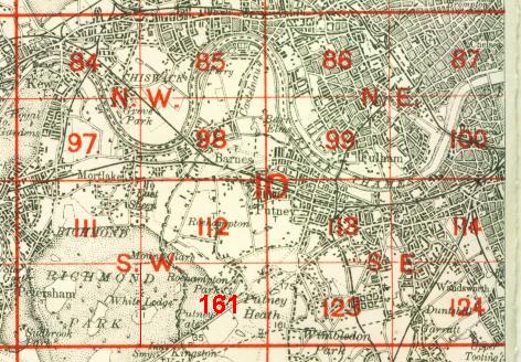
The map links up with
London Sheets 113 Putney to the north, 133 Wimbledon to the south, 161 Putney Vale to the west, 124 Wandsworth Common to the east.
 Follow this link for a complete list of our London maps .
You can order maps direct from our On-line Mapshop.
For other information and prices, and other areas, go to The Index Page.
Follow this link for a complete list of our London maps .
You can order maps direct from our On-line Mapshop.
For other information and prices, and other areas, go to The Index Page.
Maps in the Godfrey Edition are taken from the 25 inch to the mile map and reduced to about 15 inches to the mile.
For a full list of maps for England, return to the England page.
Alan Godfrey Maps, Prospect Business Park, Leadgate, Consett, Co Durham, DH8 7PW /
sales@alangodfreymaps.co.uk / 22 February 2018
 Follow this link for a complete list of our London maps .