Old Ordnance Survey Maps of Buckinghamshire

  • These detailed maps normally cover an area of about one and a half miles by one mile. Each map includes an introduction.
  • They are available through our On-line Mapshop

  • Here are the details of maps for Newport Pagnell:

  • Buckinghamshire Sheet 10.02 Newport Pagnell 1899 - published 1993; intro by Edward Legg. ISBN.978-0-85054-561-6

    This detailed map covers the town of Newport Pagnell, which took its name from its owner Fulk Paynel, whose family were also responsible for the foundation of Tickford Priory. Features on the map include the town centre, St Peter & St Paul's church, Tickford Bridge, High Street, Silver Street, River Ouse, railway station, Old Shipley Wharf, Caldecote Street, North Bridge, brewery, Castle Meadow, Tickford Abbey, Tickford Lodge, Tickford End. At the top of the map is Lathbury House and All Saints church. A directory of Newport Pagnell in 1896 is on the reverse.

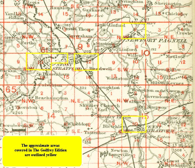
    You might find this index map useful.


  • Follow this link for a complete list of our Buckinghamshire or Milton Keynes maps.
  • You can order maps direct from our On-line Mapshop. For other information and prices, and other areas, go to The Index Page.
  • Most maps in the Godfrey Edition are taken from the 25 inch to the mile map and reduced to about 15 inches to the mile. For a full list of maps for the Buckinghamshire region, return to the Thames & Chilterns page
    The Godfrey Edition / sales@alangodfreymaps.co.uk / 27 January 2018