Old Ordnance Survey Maps of Wakefield


  • For the central area of Wakefield we have reprinted some of the very early Five-foot plans. Originally published at a scale of 1:1056 or 5 feet to the mile, we have reduced them in scale to 1:1760 or a Yard to the Mile. The maps, though covering quite a small area, are very detailed, even including the interiors of some public buildings, such as churches. For the urban historian they are perhaps the most fascinating maps ever published by the Ordnance Survey.
  • Each map includes a specially written introduction to the area. Maps can be purchased on our On-line Mapshop where further information about titles is given.

  • Here are the details of maps for Wakefield NW:

  • Wakefield 4 Wakefield NW: Wood St & the Corn Market 1848-66 - published 2023; intro by Alan Godfrey. ISBN.978-1-78721-677-8

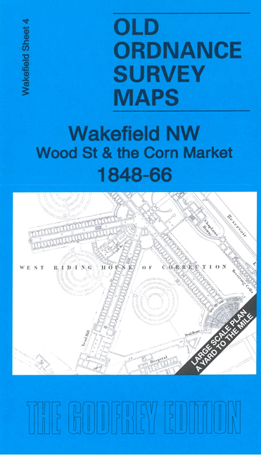
    This wonderfully detailed map covers the western part of the city centre.

    A major feature is the prison (or West Riding House of Correction). The map also includesd the Wood Street area, Corn Market, Bull Ring, Zoological Gardens, Court House, and extends to the W end of All Saints church (today's Cathedral).

    On the reverse we include a 1:500 plan covering the area from Westgate station to the Market Cross in 1888, together with a 2,000 word introduction to the history of the area.

    The map links up with Sheet 7 Wakefield SW to the south.


  • Follow this link for a complete list of our Wakefield Series maps. For other information and prices, and other areas, go to The Index Page.
  • This map is taken from the OS 5 foot plan map and reduced to a scale of A Yard to the Mile.' For a full list of maps for England, return to the England page.
    Alan Godfrey Maps, Prospect Business Park, Leadgate, Consett, Co Durham, DH8 7PW / sales@alangodfreymaps.co.uk / 3 August 2023