Old Ordnance Survey Maps of West Sussex
We have a range of detailed maps for West Sussex towns, and we also cover the whole county at the Inch to the Mile scale.
All maps are available from our On-line Mapshop.
West Sussex is a two-tier county, with a county council and seven districts. Visit This Page for a summary of the county's local government history.
For maps of East Sussex see the East Sussex page.
 These are our maps for West Sussex:
We also cover the whole of Sussex in our Inch to the Mile series. These are the principal sheets for the county:
- 301 Haslemere & District 1901- Published 2003, intro by Tony Painter. Includes a map of Cranleigh
- 302 Horsham, Crawley & St Leonard's Forest 1901 - published 2004, intro by Tony Painter. Includes a map of Slinfold
- 303 Tunbridge Wells & Ashdown Forest 1894 - published 2011; intro by Barrie Trinder. Includes a map of Mayfield
- 304 Tenterden & District 1893 - published 2010; intro by Barrie Trinder. Includes a map of Hassocks
- 316 Fareham, Hambledon & Havant 1894 - published 2011; intro by Barrie Trinder. Includes a map of Hambledon
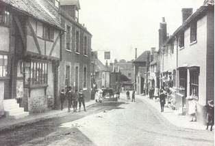
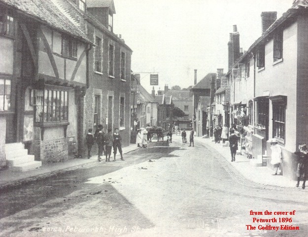
- 317 Arundel & District 1881 - published 2010; intro by Barrie Trinder. Includes a map of Arundel
- 318 Brighton & District 1894 - published 2010; intro by Barrie Trinder. Includes a map of Hassocks
- 319 Lewes & District 1894 - published 2010; intro by Barrie Trinder. Includes a map of Westham inc; Pevensey Castle
- 320/321 Winchelsea, Hastings & Dungeness 1903 - published 2004, intro by Tony Painter. Includes a detailed
map of Winchelsea
- 332/333 Selsey Bill, Bognor & Worthing 1901 - published 2005, intro by Tony Painter. Includes a map of Pagham.
- 334 Beachy Head, Newhaven & Eastbourne 1880-1903 - published 2005; intro by Tony Painter. Includes a map of Litlington. NB. This
title includes two different dates for sheet 334, so you can see the changes from 1880 to 1903.
See the One Inch page for a complete list.
 Most maps in the Godfrey Edition are taken from the 25 inch to the mile map and reduced to about 15 inches to the mile.
For a full list of English maps, return to the England page
This list shows all our maps for the area. We try to keep a full range in print but inevitably some titles fall out of print from time to time.
These are noted in our On-line Mapshop.
Most maps in the Godfrey Edition are taken from the 25 inch to the mile map and reduced to about 15 inches to the mile.
For a full list of English maps, return to the England page
This list shows all our maps for the area. We try to keep a full range in print but inevitably some titles fall out of print from time to time.
These are noted in our On-line Mapshop.
Alan Godfrey Maps, Prospect Business Park, Leadgate, Consett, DH8 7PW. Tel 01207 583388
The Godfrey Edition / sales@alangodfreymaps.co.uk / 22 March 2024
 These are our maps for West Sussex: