We have very good coverage for Kirklees Metropolitan Borough, which was formed in 1974 from the Dewsbury and Huddersfield County Boroughs, Batley and Spenborough Municipal Boroughs, and Colne Valley, Denby Dale, Heckmondwike, Holmfirth, Kirkburton, Meltham and Mirfield Urban Districts.
The following titles are all taken from the OS 25" maps and reduced to a scale of approximately 14 inches to the mile. Each covers an area of a mile and a half by one mile, and includes an introduction. Click on the links below for further details. All maps are available from our On-line Mapshop.
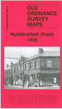 Here are the details of maps for Huddersfield (E):

This detailed map covers the east part of Huddersfield around Moldgreen and Greenside, including part of Dalton parish. Coverage stretches from Church Road Moldgreen eastward to Waterloo Bridge, and from Long Lane southward to Almondbury Bank.
Features include Christ Church, Grove Place area, Greenside Mills, Ravensknowle Hall (now Tolson Museum), Upper Bank Field Mills, Kidroyd, tramways, Oaklands, Tandem, Huddersfield Sanatorium, Waterloo Bridge Works, Dalton Green, Swedenborgian church, Dalton Mills, Dalton Dye Works, Lower Hill Top, schools etc. On the reverse we include a selection of street directory entries, including Almondbury Bank, Broad Lane, Brook Street, Victoria Street, Wakefield Road.
The map links up with sheet 246.15 Central Huddersfield to the west.